Kagera
The green, rainy north-west corner of the country, where Tanzania meets Uganda, Rwanda and Burundi — the land of the Haya kingdoms, of banana gardens and robusta coffee, and of the war that gave the region its name.
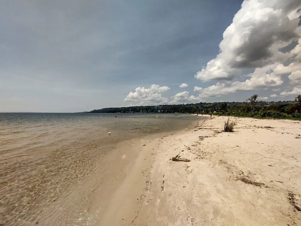
The shore of Lake Victoria at Bukoba. The regional capital sits on the western side of the lake, closer to Kampala than to Dar es Salaam.
- Region
- Kagera Region, north-west
- Population
- 2,989,299 (2022 census)
- Area
- 35,686 km²
- Capital
- Bukoba, on Lake Victoria
- Borders
- Uganda, Rwanda and Burundi
Kingdoms, a war, and a name
This was the country of the Haya kingdoms — a set of small, well-organised states on the western shore of Lake Victoria — and, to the west, of Karagwe, whose king Ndagara ruled from about 1820 until 1853 and was succeeded by Rumanyika. Karagwe lay on the caravan road to Buganda, and its rulers were the hosts every nineteenth-century European expedition to the lake had to deal with.
Under colonial rule and for the first decades of independence the area was called West Lake Region. Its present name comes from the Kagera River, which forms the border with Rwanda — and from the war fought over it.
In October 1978 Ugandan forces under Idi Amin invaded and occupied the Kagera Salient, the wedge of Tanzanian land north of the river, and Radio Uganda announced that the border had moved. Tanzania declared war, drove them out, and went on: a combined Tanzanian and Ugandan rebel force took Kampala in April 1979 and Amin fled. Tanzania lost 373 soldiers and around 1,500 civilians, the war wrecked an already fragile economy, and Kagera itself was left badly damaged. The region was renamed afterwards.
Two later disasters are still remembered here. The ferry MV Bukoba sank on the crossing to Mwanza on 21 May 1996; the official death toll was 894, and the real figure is thought to be higher. And on 10 September 2016 a magnitude 5.9 earthquake struck near Nsunga, killing at least 19 people and destroying hundreds of houses in and around Bukoba.
Bananas, coffee and the lake
What the region produces
- Coffee
- Robusta — among the country's largest crops
- Bananas
- The staple food and the landscape
- Fishing
- Nile perch and dagaa on Lake Victoria
- Pulses & maize
- Grown across the region
- Trade
- Borders with three countries
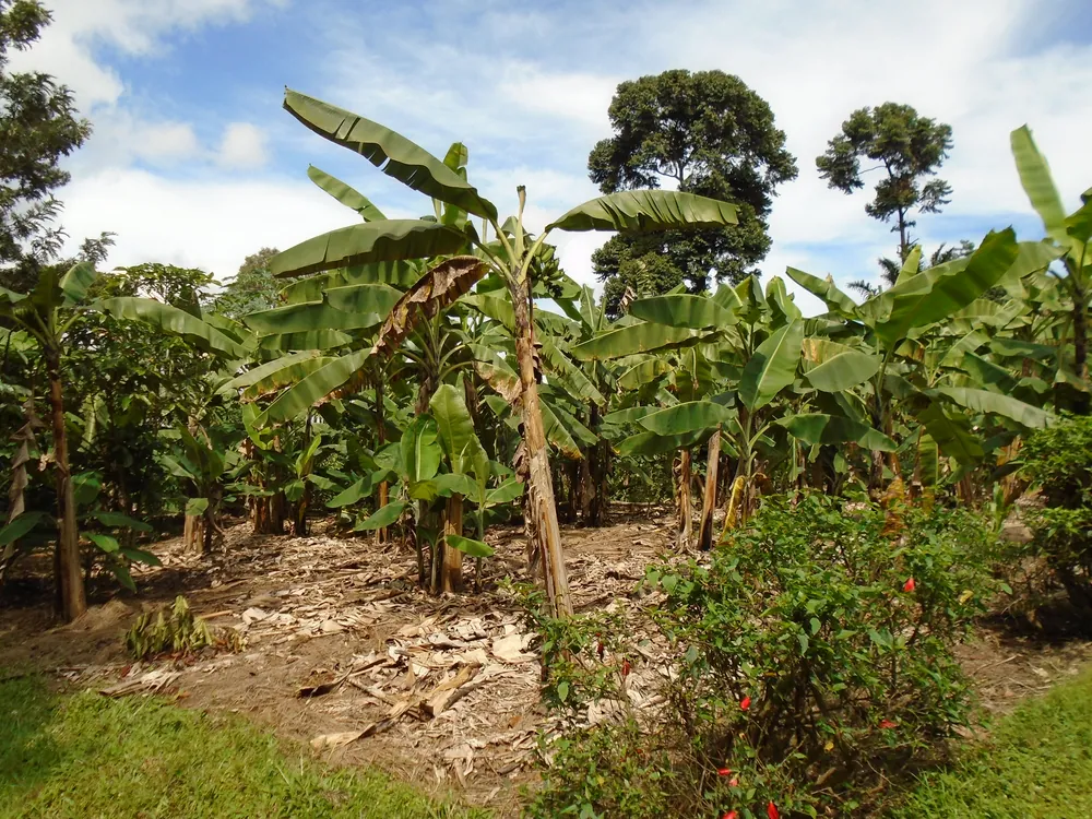
Kagera is one of the wettest regions in Tanzania, and its farming reflects it. The characteristic unit is the kibanja: a dense, permanent garden of bananas with coffee grown beneath them, mulched and manured year after year on the same ground. Bananas are the staple food — eaten cooked, not sweet — and robusta coffee is the cash crop that pays for everything else.
The lake is the other economy. Bukoba and the shoreline villages fish for Nile perch and dagaa, and the catch moves by road and by boat to Mwanza and beyond.
Three international borders make trade a business in itself. Roads run north to Uganda through Mutukula, west into Rwanda at Rusumo on the Kagera River, and south-west to Burundi through Ngara, and a great deal of small-scale cross-border commerce moves along them.
Haya country
The Haya are the largest people of the region, with the Nyambo in Karagwe, the Subi, Zinza and Hangaza elsewhere. Haya society was organised around the kingdoms, and something of that formality survives in how the region presents itself — in the weight its churches and schools carry in local life.
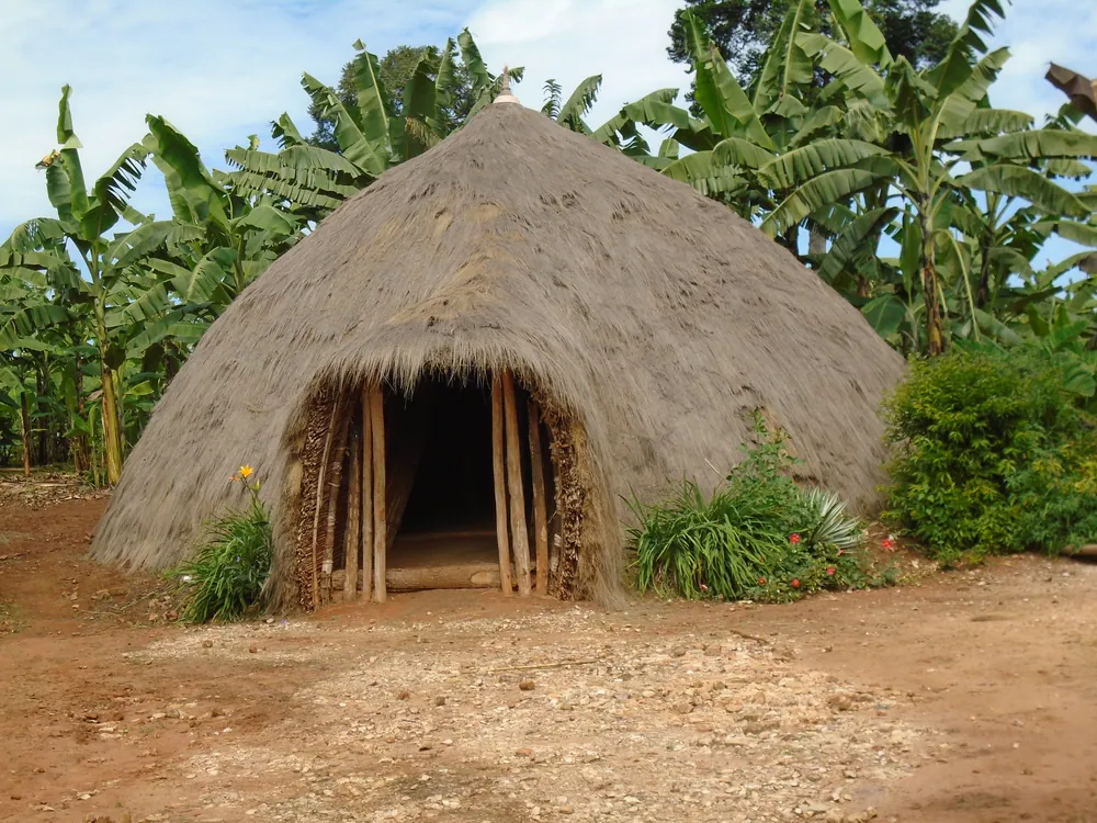
The Mushonge museum on the Kamachumu plateau holds a reconstructed royal house of the kind the Haya kings lived in: a great domed structure of poles and grass, built without nails and dark inside as a cathedral.
Bukoba itself is a small, green, unhurried lake town — a cathedral, a market, a long beach, and a waterfront where the lake looks like the sea. It is a full day's sail or a short flight from Mwanza, and psychologically closer to Kampala than to Dar es Salaam.
Towns, parks and places across Kagera Region
Historic district
Karagwe
The old kingdom west of Bukoba, on the caravan road to Buganda. Rolling, hilly country with a long history of cattle-keeping.
National park
Rumanyika-Karagwe National Park
Gazetted in 2019 on the old royal hunting grounds of Karagwe, in the west of the region.
National park
Burigi-Chato National Park
A large park of woodland, lakes and swamp between Lake Victoria and the Rwandan border, gazetted in 2019.
National park
Ibanda-Kyerwa National Park
A small park on the Kagera River in the far north-west, also gazetted in 2019.
Border district
Ngara and Rusumo
The south-western corner, on the Kagera River crossing into Rwanda — and the district that took in enormous refugee camps in 1994.
Forest
Minziro Forest Reserve
Swamp forest on the Ugandan border in Missenyi, with birds and butterflies found almost nowhere else in Tanzania.
Informational — none of this is ticketed by us
Lakeshore
Bukoba lakefront
A long sand beach and a working fishing shore, in easy walking distance of the town centre.
Heritage
Mushonge museum, Kamachumu
A reconstructed Haya royal house on the plateau above Bukoba, with the region's history around it.
Farming landscape
The kibanja gardens
Banana and coffee gardens covering whole hillsides — the everyday landscape of Haya country.
National park
Burigi-Chato National Park
Woodland, lakes and swamp, still very quiet — one of the parks gazetted in 2019.
National park
Rumanyika-Karagwe National Park
The old Karagwe royal hunting country, west towards Rwanda.
Forest
Minziro Forest
Guinea-Congo swamp forest at the Ugandan border — birding country, and unlike anywhere else in the country.
Before you go
- Getting there
- Bukoba has an airport with scheduled flights, and ferries cross Lake Victoria to Mwanza. By road it is a long drive around the lake.
- Getting around
- The parks and Karagwe need a vehicle and a driver; rural roads are slippery in the rains.
- When to come
- There is no long dry season here. June to August and December to February are the driest spells.
- Climate
- Warm, humid and green, at about 1,100 m on the lake shore. Expect rain in any month.
- Borders
- Uganda, Rwanda and Burundi are all close. Carry your passport when travelling near the borders.
- Money
- Shillings. ATMs in Bukoba; carry cash everywhere else.
Last reviewed 2026-09-17
Editorial — fact-check complete
Checked against
- 2022 Population and Housing Census — administrative unitsNational Bureau of Statistics, Tanzania
- Kagera Region — area, districts, economy, parksWikipedia
- Uganda–Tanzania War — the Kagera Salient, 1978–79Wikipedia
- MV Bukoba — the 1996 sinkingWikipedia
- 2016 Tanzania earthquakeWikipedia
- Karagwe District — Ndagara and RumanyikaWikipedia
- National parks of TanzaniaTanzania National Parks (TANAPA)